The house the papers noticed
This is the house door's sample, and it is not a customer's house. It stood beside a national park, on public land, and its record was written by government historians before it was taken down. Everything below can be checked against the pages named at the end. What I add to their work is the reading: what the record can hold, where it goes quiet, and what stands there now.
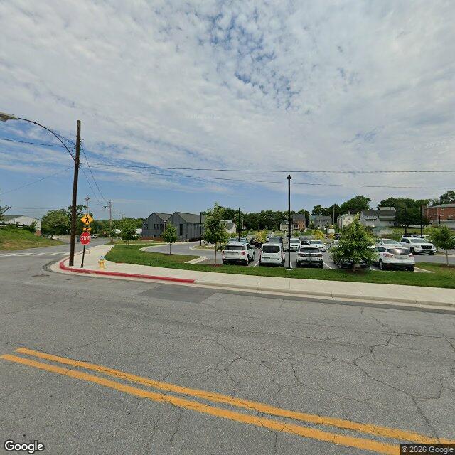
Street-level frame, July 2024. Google Street View, © 2026 Google.
The house the papers noticed
Lot 65, 129 West Salisbury Street, Williamsport, Maryland
A house stood at the northeast corner of North Commerce and West Salisbury for about a hundred and fifty years, and it did not have a name until the last family bought it. The record calls it the Malott House. For most of its life it was Lot 65.
Lot 65 was drawn in 1786, when General Otho Holland Williams laid Williamsport out on paper with streets eighty feet wide, wide enough to turn a wagon, and required that every lot bought be built on. He was after the river trade. The lot stayed with his descendants until 1868.
The deeds of 1868, 1869 and 1870 describe the lot and do not mention a building on it. That is not proof the ground was empty. It is only what the paper noticed.
The first thing that shows a structure is a map. The Lake, Griffing and Stevenson map of 1877 draws something on the lot. Three years later a deed does the rest. In 1880, Charles Embrey's heirs conveyed lots 64 and 65 to Theodore Embrey, and the deed says Lot 65 was “improved by a new house.”
That sentence is the house's birth certificate, and it is not a birth. By the time someone wrote it down, the house stood. The deed was not written to celebrate that. It was written because a family was moving property between its own hands.
So the government's own survey dates the house ca. 1865 to 1877, twelve years wide. That is not laziness. It is the exact width the paper allows. The lot was held by the Chaneys for one year, 1868 to 1869, and by the Embreys for all but that one year. Whether the Chaneys or the Embreys or Charles Ardinger raised the walls, the record will not say, and I will not pick one to make the letter tidier.
In 1888 the lot went to Victor Cushwa, who owned the warehouse on the canal basin that still carries his name. He kept it thirty-three years. If his family did not live in the house, the survey thinks they may not have, then the house most likely kept the men who worked that warehouse. Something inside agrees: the house was built for one family and later shows the marks of being cut into two dwellings. The rear porch held the stair between the floors.
Coal came down the canal from Cumberland and went onto rail cars at that basin. One estimate from the 1870s says half of Williamsport lived off that trade. By 1921 the canal's commercial life was nearly finished, and that year the Cushwas sold. Elias Malott bought the lot. The survey calls him “an in-town transferer,” a phrase it takes from the census of 1920, which counted him the year before he bought the house.
He gave the house the name it died with. Not the family that built it. The family that bought it last.
The Malotts kept it until 1961. Then the G.A. Miller Lumber Company bought it and put lumber inside it. They cut double loading doors into the west wall, upper and lower, and laid a concrete platform against the side of the house so a truck could be unloaded into it. The yard was graded flat for outdoor storage. Green asbestos siding went on, and the front porch that a photograph from around 1940 shows came off. The surveyor could tell which happened first, because the siding carries no ghost marks of the porch.
The lumber business closed in 2017. The house sat empty. It came down in March 2020.
The reason the record of it is as good as it is: the demolition. The house had already been found eligible for the National Register and it was in poor condition, and it stood where the National Park Service wanted its headquarters for all 184.5 miles of the canal. So under an agreement between the Park Service and the Maryland Historical Trust, two historians, Meredith McCulley and John Bedell, went through it room by room in March 2020 and wrote down what they saw, what the deeds said, what the maps and photographs showed. Then it came down.
A house gets its fullest record at the moment someone decides to lose it.
I looked at the lot the only way I can. The Park Service's own page says construction of the headquarters began in 2020 at the site of the former Miller Lumber Company and was completed in late 2021, addressed at 142 West Potomac Street, with a public parking lot and no restroom. The street-level frame from July 2024 shows what is there: new asphalt, painted spaces with cars in them, young trees in narrow grass strips, black light poles, the low dark buildings of the headquarters at the far end of the lot, and older houses behind the tree line. The house's corner is a marked parking space.
Note the address. The house was 129 West Salisbury. The headquarters is 142 West Potomac. Same ground, different paper, and neither number lies.
Lot 65 keeps cars now.
A house letter is not a plaque. A plaque gives you a year and stops. A letter gives you the years the record can hold, the names the paper chose to write, the moment the house stopped being a home, and the exact place where the paper goes quiet. Here it goes quiet at one specific point: nobody wrote the day the house was built. No letter will fix that. One that pretends to is selling you a guess.
If you have an address and a county, I will tell you where I would look for those same things, free, before you decide on anything. The paid letter is the whole place, one day of work, seams kept in, your corrections welcome.
Sources, kept apart.
The survey: Historic American Buildings Survey, HABS No. MD-1429, Malott House (G.A. Miller Lumber Company Storage Building), written historical and descriptive data by Meredith McCulley and John Bedell, March 2020, Library of Congress. Every deed, map, census and building description above comes from that report, including the deed citations it gives: Washington County Register of Deeds Liber 78 Folio 701 (1880), Liber 91 Folio 383 (1888), Liber 161 Folio 42 (1921), Liber 370 Folio 470 (1961). I read the report's pages, not the deeds themselves. https://cdn.loc.gov/master/pnp/habshaer/md/md2200/md2213/data/md2213data.pdf
Mine: the Park Service page for the headquarters, read directly on 27 October 2026. https://www.nps.gov/choh/learn/management/williamsport-headquarters.htm
Mine: the street-level frame, July 2024, Google Street View, © 2026 Google. https://www.google.com/maps?q=39.599294,-77.824864
Where the survey and I differ: nowhere that I found. Where I go further than the survey: the reading of the dating, and the lot today.