OpenStreetView is not an Alternative to Google Maps
It is more than fair to criticize Google and its services for violating data privacy en masse and it is also fair to mock Apple Maps for plain wrong entries, so it might come as a surprise to those using the free “alternative”, OpenStreetMaps (OSM), is a confusing a badly-maintained mess.
OSM behaves similar to Wikipedia, though with two significant differences:
- OSM is more open to primary (local) sources,
- OSM isn't actually meant to be an alternative to Google Maps and avoids standardization.
The latter is the most important point, which explains the lack of adaptation among sole users and those wanting to contribute to it. Especially smaller villages will take the short end of the stick, should interested inhabitants decide to contribute themselves.
Only Google Maps knows the Natural Conservations – and even better than our Government
Today, I decided to create a profile, as I was getting annoyed by many aspects of my home village missing entirely or being poorly documented, while irrelevant things that have also been included with plain wrong labels entered the database years ago without any checks.
To explain: There are two nature conservations just north from my village, which haven't been given a name by OSM and were poorly studied by the Thuringian Ministry of Environment and Natura 2000. Using the available data, I began to redraw the grassland most affected by OSM's lack of care and removed trees that aren't highlighted in the official Natura 2000 documentation, as the classification of those areas as orchards is a matter of dispute. One long-time user immediately advised me to revert these changes on the basis that “satellite photos show trees in that area” and advised me to highlight single trees of potential significance and describe the track towards this conservations (which was impassable prior before our government decided to put a sign up, almost over a decade after it was declared a natural conservation that still is largely unknown to locals). Mentioning that I have been living here for more than 20 years did not settle the dispute, however.
A Private Pool is more important than a Car Repair
That was another thing bugging me massively: Whoever attempted to map my village did it in such a poor fashion that they labeled one private pool out of dozens of unmapped ones as “public” without anyone from OSM noticing it. Since only one pool was mapped, I decided to remove it in order to also encourage more users to get other, more important things mapped first, such as the existence of two new homes that were built around 2017 (five years ago!), an abandoned pond formerly used by our local fire department, and a natural monument that lost its typical “owl sign” due to indifference from locals (especially former mayor of our municipality) a decade ago. The user from earlier advised me to remap the private pool and simply set the label to “private”, without giving any attention to two other private pools located just a few meters away from the mapped one. If other pools would have been mapped, I could understand his motives but it was just one pool and, not surprisingly, the one owned by the family of a former classmate of mine. It is possible that my former classmate added it and ignored the setting that would label it as private property – no other contributor even noticed this until my edit. Things got even stranger when I noticed that adding the local car repair that has been active since German reunification was accepted without any manual checks and was missing for so long, while benches not even used by locals and in neglected conditions were mapped.
Another user then commented, stating that OSM is not supposed to be “an alternative to Google Maps but a database for navigation systems”. This comment would not be so frustrating if the homepage of OSM would not state “OpenStreetMap is a map of the world, created by people like you and free to use under an open license”. Two users were more bothered by me attempting to include more relevant data than Google Maps for people ever ending up in my village and locals alike, yet got nudged into re-mapping a bunch of bushes that also grow between farmlands across the entire area – and right between already-mapped areas that cannot mapped separately – and one single swimming pool.
Due to possibly appearing as a vandal if I should do all necessary edits in one sitting, I decided to pause things and eventually deleting my profile.
Perhaps it is just German FOSS users, notorious for preventive-protecting Wikipedia articles every time users assume a future edit war, that do not make OSM attractive in Germany. Two users alone, who have not even been to my village, let alone ever heard of it until I began to edit it, might have had good intentions, though it was not just their “recommendations” that were strange at best; the first commenter made clear to be relying solely on the official wiki of this project and his feelings, starting the comment with “I think”, the other highlighted that “bushes do not have to be of biological significance” – I genuinely thought this was an Open Source map depending highly on locals and a certain sense of completeness of relevant data, not some place for FOSS fans trying to enforce a standard that is confusing, beyond messy, and hidden in a wiki not linked on the homepage and not recommended when signing up.
Even Competitors noticed the Poor Quality
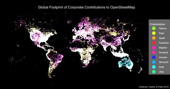
“OpenStreetMap’s data is crowdsourced, which has always made spectators to the project a bit wary about the quality of the data,” says Dipto Sarkar, a professor of geoscience at Carleton University in Ottawa, and one of the paper’s co-authors. “As the data becomes more valuable and is used for an ever-increasing list of projects, the integrity of the information has to be almost perfect. These companies need to make sure there’s a good map of the places they want to expand in, and nobody else is offering that, so they’ve decided to fill it in themselves.”
As of 2021, only 20% of OSM's five million registered users actively contribute to the project, meaning that only one million users are mapping the globe. The paper cited by Bloomberg includes an additional graph, highlighting how big companies are responsible for “nearly 17% of all edits between March 2019 and 2020 came from corporate teams”.
The same article mentions a contributor a Germany that summarizes my personal experiences:
“Maps can never be a perfect representation of the world — they are instead a representation of how the map-makers perceive the world,” Frederik Ramm, a longtime OSM volunteer and software developer in Germany who also runs an open-mapping consultancy, said. “These companies don’t map for the same reasons we do, and because of that, I question deeply if our goals can align.”
The issue that not even long-time OSM contributors fail to acknowledge is the lack of direction – is it really just a database or a serious alternative to popular maps? – and lack of sufficient standards that are being enforced in all cases, and an even bigger lack of contributors encouraging people outside of FOSS forums to contribute and provide a more welcoming editor (even as a heavy internet user able to install Arch Linux and read traditional maps, the way OSM wants buildings to be mapped by drawing was beyond frustrating).
Earlier research has shown that OSM is much less inclusive than it purports to be: European and North American men predominate as editors, with far less participation from women and mappers in the developing world. In that sense, conflicts over corporate editors are an extension of a bigger, older question of what OSM is — and more importantly, who gets to define it.
To summarize, it is largely driven by male FOSS fans from larger cities. Just earlier, I told a male biology student – a good friend of mine – about my experiences with OSM and he let me know that he has to use Google Maps to map rare sightings. His university does not encourage to usage of OSM or services almost exclusively relying on their data, and OSM does not want that kind of data.
A Map should be created and maintained by Cartographers and Locals, not Software Developers
Being a FOSS user myself, I am quite familiar with the drawbacks of certain FOSS projects and thus advise others asking me for guidance to use software that poses the least trouble end-user-wise. If my friend would seek advice on which “digital darkroom” he should use to process his photos of snakes and insects, I would recommend Adobe Photoshop Lightroom to him, as the FOSS alternative darktable cannot keep up with what LR has been capable of for years, including the management of presets. More often than not, FOSS projects, especially those self-branding themselves as “Beginners-friendly”, suffer from the fact that they do not understand the common computer user and accidentally make their projects unnecessary more complicated even for more experienced users. This is especially the case for Linux distributions like elementary OS, and so it appears the case for projects like OpenStreetMap. While eOS is an operating system, OSM oftentimes poses as prime example of the downsides of “crowd intelligence”. One really has to give credit to Wikipedia, another FOSS project, for having learned from their mistakes and providing decent moderation and formal rules – OSM still lacks these, despite being founded just three years after Wikipedia.
OSM also takes the cake in terms of the technical requirements: While I could edit my village's Wikipedia article using my ten-year-old dual-core laptop, OSM brought my old device close to overheating due to demanding more than 60% of CPU resources. A paper published by Matthias Plennert in 2018 analyzed the data structure in OSM and should be read in its entirety:
The software infrastructure is growing and stagnating at the same time: while new parts are constantly added to the project, the software core remains in its original design since 2007. Thus, the ongoing software development in OSM is characterized by new additional features and tools, which mostly access the old core of OSM via the database or the application programming interface (API). The design of the API reflects the design of the database: if the structure of database changes, the API must change as well to make new database features available. Though, as Table 3 shows, the API, as well as the strongly related database itself, were not significantly modernized, reengineered or adapted to new needs since the release of API version 0.5 in October 2007 (the API was last amended in April 2009, however this release included only minor changes). This lack of change becomes particularly obvious when looking at the OSM data structure, respectively, its data-model. From 2004 to 2007, the data-model underwent several changes: between version 0.3 in March 2006 and 0.5 in October 2007, major modifications were carried out. However, since the last documented API change to version 0.6 in April 2009 with minor adjustments, the data-model remains unmodified.
To take this fact a little further, OSM does not care about the quality of its content or even the quality of its underlying software. In fact:
The ‘rules of play’ and rules of access in OSM comprise decision-making and driving forces. As mentioned before, the decision-making in OSM is based on do-ocracy and thus favours those who have the technical skills, understanding and time for carrying out changes in the software. Although this decision-making was openly criticized by some members of the community 25 as undemocratic, this mechanism is still commonly accepted by the community.
Less tech-savy users, which represent the majority of humans, do not really have a say regarding the structure of OSM. This is similar to the effects of DRM: It only punishes the less-skilled with legal intentions. Even though OSM needs less tech-savy contributors to improve their services in rural areas across the globe, this appears to not be in interest of the hobbyist developers still perceiving OSM as a small, fun project made for and by hobbyists and few big players.
It is ridiculous enough that my own government is unable to provide a map of our nature conservations that does not accidentally include private-owned farmland, it's even more ridiculous that services like OSM are even poorer than Apple Maps in rural regions in densely-mapped countries. The project is largely driven by its users, which shows that each user has its own motives for contributing. This makes OSM a messy place with a biased approach to mapping driven largely by relatively few software developers from Western cities and big companies aspiring to increase their profits. From the perspective of big players and end-users, the big players win:
I remember just a few years ago, I got a new phone and was interested in replacing as many Google apps with OSS maps that I could. (K9 instead of Google's mail app, etc.)Naturally I turned to OSM instead of Google Maps. But I was really surprised by how strange and difficult it was to install and use. As the author mentioned, OSM itself doesn't have any apps, which is very confusing. After some research I figured out that you have to download a 3rd party app. The 3rd party apps that do exist all use different terminologies, require downloading huge amounts of data and picking what maps you want ahead of time, and had different levels of functionality. The UIs were universally terrible (at the time at least). Needless to say, I quickly gave up on using OSM and turned back to Google Maps—and I'm their perfect use case, a skilled techie with a deep interest in using free software! I can't imagine trying to explain how to use OSM to my mom, even if I somehow managed to install it for her.
Addendum (21 May)
Just a few hours ago, I passed both natural conservations during a car ride and did not even have to stop and approach it to notice that the satellite photos OSM relies on must be, for digital standards, horribly outdated. And indeed, the satellite photos are not only provided by Microsoft Bing but also from 2018, when eastern parts of Germany experienced a drought lasting several months. The first point is quite funny: OSM is supposed to be a FOSS project; its own community treats it as a FOSS database merely to be exploited by commercial apps and services but complains when big companies like Microsoft actively contribute to it and thus give something back to the community. OSM and its community are dependent on big companies.
The second point is something someone will only notice when comparing different satellite photos. While Bing pictures the surrounding area of my village as a bunch of separate hay fields, Google Maps shows that there is far more green even on farmland and the unnamed and private-owned hill right behind my home, and that there are far more prominent trees and bushes within the area of the other protected area. Even worse, the natural conservation we were fighting over has lost a noticeable amount of trees and bushes, with signs of vehicles having driven through the protected area to reach a field – the same field OSM, my government, and Natura 2000 classified as part of the protected area. Everyone failed to map this area correctly, with the exception of Google, that did not highlight both grasslands at all. Given that no one really seems to know how much land the natural conservation actually encompasses and which parts possibly are private property, the way Google handles it is far more reasonable than mapping something that has changed significantly within four years and possibly could encourage the violation of property rights.
The remaining trees and bushes, ironically enough, cannot be mapped separately due to overlapping with the edges of the mapped “grassland”. There also is an area of several tiny but prominent bushes right between the natural conservation and a field that also cannot be mapped due to the same issue of OSM not allowing overlapping types of land. It also does confirm my suspicion that some random guy from a large town outside of Thuringia opened OSM, checked Bing Maps, saw those rather tiny areas on the grassland, and mapped them without checking if the provided satellite photos are up-to-date or if this area possibly could be part of a project like Natura 2000. Outside of popular places, OSM members map things how they want with as little care as possible and not taking relevance, actuality, and status into account.
And honestly, I had to chuckle when I noticed that Kachelmannwetter, a weather service headquartered in Switzerland, uses an even older database provided by OSM that does not include both natural conservations at all.